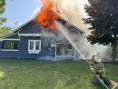
The National Weather Service has field teams in Southwest Michigan this week, looking into reports of several tornadoes in Cass, Van Buren, St. Joseph, and Kalamazoo counties.
Meteorologist Chris Roller tells us the fierce storms that rolled into the region were indeed unusual.
“We had enough energy in the atmosphere and we had some pretty strong wind dynamics that were around to support storms of that strength,” Roller said. “Very strong winds at the low levels to be able to do that, in the low levels of the atmosphere.”
Roller says in addition to the tornadoes, the high energy of the storm is highlighted by the golf ball-sized hail that came with it.
“It tells us that the updraft, the thing that get the clouds bubbling within the storm, is very strong and is able to sustain some of the higher end severe weather.”
The hail was even larger in parts of Indiana.
Roller reminds everyone to know the difference between a tornado watch and a tornado warning. He says a watch is when all the ingredients for a tornado are present, but one hasn’t been actually spotted. A warning is issued when someone has either seen an actual tornado, or when radar shows one.
When a watch is in place, be ready and pay attention to further announcements. When a warning is issued, take cover.